by Lee Humphries: Director PWPA, National Geographic Certified Outdoor Educator
I remember when I first learned in Grade Three that the way through Canada was made by the water. All the explorers, traders, rail lines, roads….ALL follow the waterways.
According to local historian Richard Smith, Greata Creek is on an old trade trail between the Coast and Interior Salish where the Okanagan peoples brought furs and interior goods to exchange for fish and cedar goods with their coastal cousins.
Known as the “Old Indian Trail”, and merging with the “Fur Brigade Trail”, today you can follow this trail by road from Peachland to Princeton. Starting at Hwy 97 and Princeton Avenue, go up!!! It’s called Princeton Avenue because it goes to Princeton!
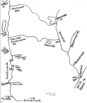
At first you will be following Peachland or Deep Creek. Note the municipal works yard on your left and shortly thereafter asphalt will turn into dirt. The Cattle guard at the beginning of the dirt is Km 0 and marked by yellow forestry KM markers. Turn LEFT at Km6 (onto Peachland Forest Service Road) and as you go down the switchback you will cross over Deep Creek and now be following Greata Creek to Glen Lake. At Km15 turn LEFT onto Glen Lake Forest Service Road and soon you will pass Glen Lake Reservoir boasting great fishing, hiking and camping. From this Height of Land the water you now see flows toward Summerland. You will be driving along the creek but keep an eye open for active logging. They always have the right of way! About 30 km later you will come out on the Summerland/Princeton Road. If you turn left it’s about 50 km to Summerland. A right turn will take you to Princeton along the Similkameen River with many good roadside stops to water watch and a tail-gate lunch. This route is open to enjoy from May to October.
08.03.21